Address: 2100 (From 2100 To 2199) BUFORD TOWN DR, BUFORD, GA 30518-0009, USA
What's 30518-0009? 30518-0009 is a ZIP Code 5 Plus 4 number of 2100 (From 2100 To 2199) BUFORD TOWN DR, BUFORD, GA, USA. Below is detail information.
30518-0009 Basic Information

-
ZIP Code 5 Plus 4:
30518-0009 -
ZIP Code 5:
30518 -
Plus 4?00094-digits that are used to identify a geographic segment within the 5-digit delivery area, such as a city block or a group of apartments or an individual high-volume receiver of mail, or any other unit that could use an extra identifier to aid in efficient mail sorting and delivery. This code is the low end of the range of +4 Codes that pertain to this ZIP Code. ZIP+4 Codes associated with nondelivery areas are composed of valid ZIP sector numbers and "ND" for the ZIP segment number, for example 12345-12ND. Non-deliverable areas are areas to which the USPS does not deliver mail, such as vacant lots and land that borders railroad tracks. Mailers should not match an address identified as a nondelivery area. If you absolutely must have numeric characters in the Plus4Code column, you may treat "ND" values as "00" (zero zero).:
-
Country:
U.S. - United States -
State:
GA - Georgia -
County:
CountyFIPS: 13135 - Gwinnett County -
City:
BUFORD -
Street?BUFORD TOWN DRThe official name of a street as assigned by a local governing authority. The Street Name column contains only the street name and does not include directionals (EAST, WEST, etc.) or suffixes (ST, DR, BLVD, etc.). This element may also contain literals, such as PO BOX, GENERAL DELIVERY, USS, PSC, or UNIT. Numeric street names that have numeric components that are four characters (or less) in length at are justified such that the low-order digit of the number is positioned in the fourth position of the street name column. This shift is made so that the numeric street names appear in numeric sequence.:
-
Street Suffix?DR (Drive)The street suffix: For Example: ST = Street RD = Road DR = Drive LN = Lane:
-
Record Type?S: StreetAn alphabetic value that identifies the type of data in the record. Record type codes include the following: G = General delivery H = Highrise F = Firm S = Street P = PO box R = Rural route/highway contract:
Address

- Address Primary Low Number?
A house, rural route, highway contract box, or post office box number; the numeric or alphanumeric component of an address preceding the street name; the low-end address in a range of addresses. Often referred to as house number.: 2100
- Address Primary High Number?
A house, rural route, contract box, or Post Office box number. The numeric or alphanumeric component of an address preceding the street name. The high-end address in a range of addresses. Often referred to as house number.: 2199
- Address Primary Odd / Even Code?
Code that identifies the side or sides of a street for which a given address range is applicable. For street, highrise, firm and multi-carrier records, B = Both sides of a street, E = Even side of a street (even-numbered addresses in the range); O = Odd side of a street (odd-numbered addresses in the range). For general delivery, post office box, and rural route/highway contract records, this code will always be "B" (both).: Both of Odd and Even
- Primary Range: 2100, 2101, 2102, 2103, 2104, 2105, 2106, 2107, 2108, 2109, 2110, 2111, 2112, 2113, 2114, 2115, 2116, 2117, 2118, 2119, 2120, 2121, 2122, 2123, 2124, 2125, 2126, 2127, 2128, 2129, 2130, 2131, 2132, 2133, 2134, 2135, 2136, 2137, 2138, 2139, 2140, 2141, 2142, 2143, 2144, 2145, 2146, 2147, 2148, 2149, 2150, 2151, 2152, 2153, 2154, 2155, 2156, 2157, 2158, 2159, 2160, 2161, 2162, 2163, 2164, 2165, 2166, 2167, 2168, 2169, 2170, 2171, 2172, 2173, 2174, 2175, 2176, 2177, 2178, 2179, 2180, 2181, 2182, 2183, 2184, 2185, 2186, 2187, 2188, 2189, 2190, 2191, 2192, 2193, 2194, 2195, 2196, 2197, 2198, 2199.
Please click the "More Address Examples" to view the whole list.
2100 BUFORD TOWN DR, BUFORD, GA 30518-0009
2101 BUFORD TOWN DR, BUFORD, GA 30518-0009
2102 BUFORD TOWN DR, BUFORD, GA 30518-0009
2103 BUFORD TOWN DR, BUFORD, GA 30518-0009
2104 BUFORD TOWN DR, BUFORD, GA 30518-0009
2105 BUFORD TOWN DR, BUFORD, GA 30518-0009
2106 BUFORD TOWN DR, BUFORD, GA 30518-0009
2107 BUFORD TOWN DR, BUFORD, GA 30518-0009
2108 BUFORD TOWN DR, BUFORD, GA 30518-0009
2109 BUFORD TOWN DR, BUFORD, GA 30518-0009
2110 BUFORD TOWN DR, BUFORD, GA 30518-0009
2111 BUFORD TOWN DR, BUFORD, GA 30518-0009
2112 BUFORD TOWN DR, BUFORD, GA 30518-0009
2113 BUFORD TOWN DR, BUFORD, GA 30518-0009
2114 BUFORD TOWN DR, BUFORD, GA 30518-0009
2115 BUFORD TOWN DR, BUFORD, GA 30518-0009
2116 BUFORD TOWN DR, BUFORD, GA 30518-0009
2117 BUFORD TOWN DR, BUFORD, GA 30518-0009
2118 BUFORD TOWN DR, BUFORD, GA 30518-0009
2119 BUFORD TOWN DR, BUFORD, GA 30518-0009
2120 BUFORD TOWN DR, BUFORD, GA 30518-0009
2121 BUFORD TOWN DR, BUFORD, GA 30518-0009
2122 BUFORD TOWN DR, BUFORD, GA 30518-0009
2123 BUFORD TOWN DR, BUFORD, GA 30518-0009
2124 BUFORD TOWN DR, BUFORD, GA 30518-0009
2125 BUFORD TOWN DR, BUFORD, GA 30518-0009
2126 BUFORD TOWN DR, BUFORD, GA 30518-0009
2127 BUFORD TOWN DR, BUFORD, GA 30518-0009
2128 BUFORD TOWN DR, BUFORD, GA 30518-0009
2129 BUFORD TOWN DR, BUFORD, GA 30518-0009
2130 BUFORD TOWN DR, BUFORD, GA 30518-0009
2131 BUFORD TOWN DR, BUFORD, GA 30518-0009
2132 BUFORD TOWN DR, BUFORD, GA 30518-0009
2133 BUFORD TOWN DR, BUFORD, GA 30518-0009
2134 BUFORD TOWN DR, BUFORD, GA 30518-0009
2135 BUFORD TOWN DR, BUFORD, GA 30518-0009
2136 BUFORD TOWN DR, BUFORD, GA 30518-0009
2137 BUFORD TOWN DR, BUFORD, GA 30518-0009
2138 BUFORD TOWN DR, BUFORD, GA 30518-0009
2139 BUFORD TOWN DR, BUFORD, GA 30518-0009
2140 BUFORD TOWN DR, BUFORD, GA 30518-0009
2141 BUFORD TOWN DR, BUFORD, GA 30518-0009
2142 BUFORD TOWN DR, BUFORD, GA 30518-0009
2143 BUFORD TOWN DR, BUFORD, GA 30518-0009
2144 BUFORD TOWN DR, BUFORD, GA 30518-0009
2145 BUFORD TOWN DR, BUFORD, GA 30518-0009
2146 BUFORD TOWN DR, BUFORD, GA 30518-0009
2147 BUFORD TOWN DR, BUFORD, GA 30518-0009
2148 BUFORD TOWN DR, BUFORD, GA 30518-0009
2149 BUFORD TOWN DR, BUFORD, GA 30518-0009
2150 BUFORD TOWN DR, BUFORD, GA 30518-0009
2151 BUFORD TOWN DR, BUFORD, GA 30518-0009
2152 BUFORD TOWN DR, BUFORD, GA 30518-0009
2153 BUFORD TOWN DR, BUFORD, GA 30518-0009
2154 BUFORD TOWN DR, BUFORD, GA 30518-0009
2155 BUFORD TOWN DR, BUFORD, GA 30518-0009
2156 BUFORD TOWN DR, BUFORD, GA 30518-0009
2157 BUFORD TOWN DR, BUFORD, GA 30518-0009
2158 BUFORD TOWN DR, BUFORD, GA 30518-0009
2159 BUFORD TOWN DR, BUFORD, GA 30518-0009
2160 BUFORD TOWN DR, BUFORD, GA 30518-0009
2161 BUFORD TOWN DR, BUFORD, GA 30518-0009
2162 BUFORD TOWN DR, BUFORD, GA 30518-0009
2163 BUFORD TOWN DR, BUFORD, GA 30518-0009
2164 BUFORD TOWN DR, BUFORD, GA 30518-0009
2165 BUFORD TOWN DR, BUFORD, GA 30518-0009
2166 BUFORD TOWN DR, BUFORD, GA 30518-0009
2167 BUFORD TOWN DR, BUFORD, GA 30518-0009
2168 BUFORD TOWN DR, BUFORD, GA 30518-0009
2169 BUFORD TOWN DR, BUFORD, GA 30518-0009
2170 BUFORD TOWN DR, BUFORD, GA 30518-0009
2171 BUFORD TOWN DR, BUFORD, GA 30518-0009
2172 BUFORD TOWN DR, BUFORD, GA 30518-0009
2173 BUFORD TOWN DR, BUFORD, GA 30518-0009
2174 BUFORD TOWN DR, BUFORD, GA 30518-0009
2175 BUFORD TOWN DR, BUFORD, GA 30518-0009
2176 BUFORD TOWN DR, BUFORD, GA 30518-0009
2177 BUFORD TOWN DR, BUFORD, GA 30518-0009
2178 BUFORD TOWN DR, BUFORD, GA 30518-0009
2179 BUFORD TOWN DR, BUFORD, GA 30518-0009
2180 BUFORD TOWN DR, BUFORD, GA 30518-0009
2181 BUFORD TOWN DR, BUFORD, GA 30518-0009
2182 BUFORD TOWN DR, BUFORD, GA 30518-0009
2183 BUFORD TOWN DR, BUFORD, GA 30518-0009
2184 BUFORD TOWN DR, BUFORD, GA 30518-0009
2185 BUFORD TOWN DR, BUFORD, GA 30518-0009
2186 BUFORD TOWN DR, BUFORD, GA 30518-0009
2187 BUFORD TOWN DR, BUFORD, GA 30518-0009
2188 BUFORD TOWN DR, BUFORD, GA 30518-0009
2189 BUFORD TOWN DR, BUFORD, GA 30518-0009
2190 BUFORD TOWN DR, BUFORD, GA 30518-0009
2191 BUFORD TOWN DR, BUFORD, GA 30518-0009
2192 BUFORD TOWN DR, BUFORD, GA 30518-0009
2193 BUFORD TOWN DR, BUFORD, GA 30518-0009
2194 BUFORD TOWN DR, BUFORD, GA 30518-0009
2195 BUFORD TOWN DR, BUFORD, GA 30518-0009
2196 BUFORD TOWN DR, BUFORD, GA 30518-0009
2197 BUFORD TOWN DR, BUFORD, GA 30518-0009
2198 BUFORD TOWN DR, BUFORD, GA 30518-0009
2199 BUFORD TOWN DR, BUFORD, GA 30518-0009
Address Example
BUFORD GA 30518-0009
UNITED STATES OF AMERICA
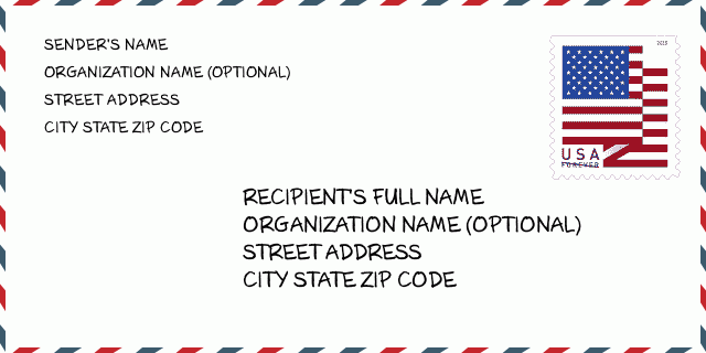
30518-0009 Envelope Example

-
This is an example of U.S envelope. Fill in the sender's information at the top left and the recipient information at the bottom right. The necessary information is sender/recipient's full name, street address, city, state and zip code. The recipient address information has been given for your reference. Generally, If you are not sure of the full 9-digit zip code, you can only fill in the 5-digit zip code to avoid loss of package.
30518-0009 Basic Meaning
-
What does each digit of ZIP Code 30518-0009 stands for? ZIP+4 Code consists of two parts, the first five digits can be located to the post office, and the last four digits can identify a geographic segment within the five-digit delivery area. The 6-7 digits designate sector or several blocks, and the 8-9 digits designate segment or one side of a street.
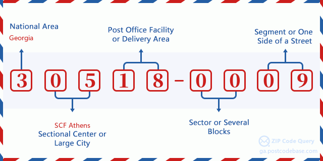

- ·Carrier Route ID?
A 4-digit code assigned to a mail delivery or collection route within a 5-digit ZIP Code. The first character of this identification is alphabetical, and the last three are numeric: Bnnn = PO box Hnnn = Highway contract Rnnn = Rural route Cnnn = City delivery Gnnn = General delivery: C007 (City delivery)
- ·ZIP Add-On Low Sector?
The ZIP Add-On Low Sector and the ZIP Add-On Low Segment together form the ZIP Add-On Low Number. The ZIP Add-On Low Number is the last four positions of a ZIP+4 code; the low-end ZIP add-on in a range of codes; the add-on of the first ZIP+4 code in a consecutive series of ZIP+4 codes assigned to the delivery address. For example, most delivery addresses are assigned a single ZIP+4 code. However, large companies may be given a range of ZIP+4 codes that can be used to route mail to specific departments. A range of ZIP+4 codes can also be assigned to a corresponding range of post office boxes, and each box is mapped, one-to-one, with a ZIP+4 code in the range. A single post office box can also be assigned a range of ZIP+4 codes.: 00
- ·ZIP Add-On Low Segment?
The ZIP Add-On Low Sector and the ZIP Add-On Low Segment together form the ZIP Add-On Low Number. The ZIP Add-On Low Number is the last four positions of a ZIP+4 code; the low-end ZIP add-on in a range of codes; the add-on of the first ZIP+4 code in a consecutive series of ZIP+4 codes assigned to the delivery address. For example, most delivery addresses are assigned a single ZIP+4 code. However, large companies may be given a range of ZIP+4 codes that can be used to route mail to specific departments. A range of ZIP+4 codes can also be assigned to a corresponding range of post office boxes, and each box is mapped, one-to-one, with a ZIP+4 code in the range. A single post office box can also be assigned a range of ZIP+4 codes.: 09
- ·ZIP Add-On High Sector?
The ZIP Add-On High Sector and the ZIP Add-On High Segment together form the ZIP Add-On High Number, which is the high-end ZIP add-on in a range of codes; the add-on of the last ZIP+4 code in a consecutive series of ZIP+4 codes assigned to the delivery address. Most delivery addresses are assigned a single ZIP+4 code; however, large companies may be given a range of ZIP+4 codes that can be used to route mail to specific departments. A range of ZIP+4 codes can also be assigned to a corresponding range of post office boxes, and each box is mapped, one-to-one, with a ZIP+4 code in the range. A single post office box can also be assigned a range of ZIP+4 codes. (See also ZIP Add-On Code.): 00
- ·ZIP Add-On High Segment?
The ZIP Add-On High Sector and the ZIP Add-On High Segment together form the ZIP Add-On High Number, which is the high-end ZIP add-on in a range of codes; the add-on of the last ZIP+4 code in a consecutive series of ZIP+4 codes assigned to the delivery address. Most delivery addresses are assigned a single ZIP+4 code; however, large companies may be given a range of ZIP+4 codes that can be used to route mail to specific departments. A range of ZIP+4 codes can also be assigned to a corresponding range of post office boxes, and each box is mapped, one-to-one, with a ZIP+4 code in the range. A single post office box can also be assigned a range of ZIP+4 codes. (See also ZIP Add-On Code.): 09
- ·ZIP Code Add On: 0009
- ·Range?
The range of +4 codes. Summing the +4 Code and the +4 Range will give you the high end of the range of +4 Codes that pertain to this ZIP Code.: 0
- ·Base Alternate Code?
Code that specifies whether a record is a base (preferred) or alternate record. Base records (represented as "B") can represent a range of addresses or an individual address, such as a firm record, while alternate records (represented as "A") are individual delivery points. Government deliveries will only be listed on alternate records with the appropriate government building indicator (federal, state, or city) set.: Base
- ·Finance Number?
A code assigned to Postal Service facilities (primarily post offices) to collect cost and statistical data and compile revenue and expense data. The state number comprises the first two positions of the finance number.: 121232
- ·Congressional District Number?
A standard value identifying a geographic area within the United States served by a member of the US House of Representatives or Senate. If Army/Air Force (APO) or fleet post office (FPO), this column will be blank. If there is only one member of Congress within a state, the code will be "AL" (at large).: 07
- ·Preferred Last Line City State Key?
An index to the City State file that provides the preferred last-line name for this address range.: X10174
Online Map

This is online map of the address 2100 BUFORD TOWN DR, BUFORD. You may use button to move and zoom in / out. The map information is for reference only.
Address: 2100 (From 2100 To 2199) BUFORD TOWN DR, BUFORD, GA 30518-0009, USA
Comment


